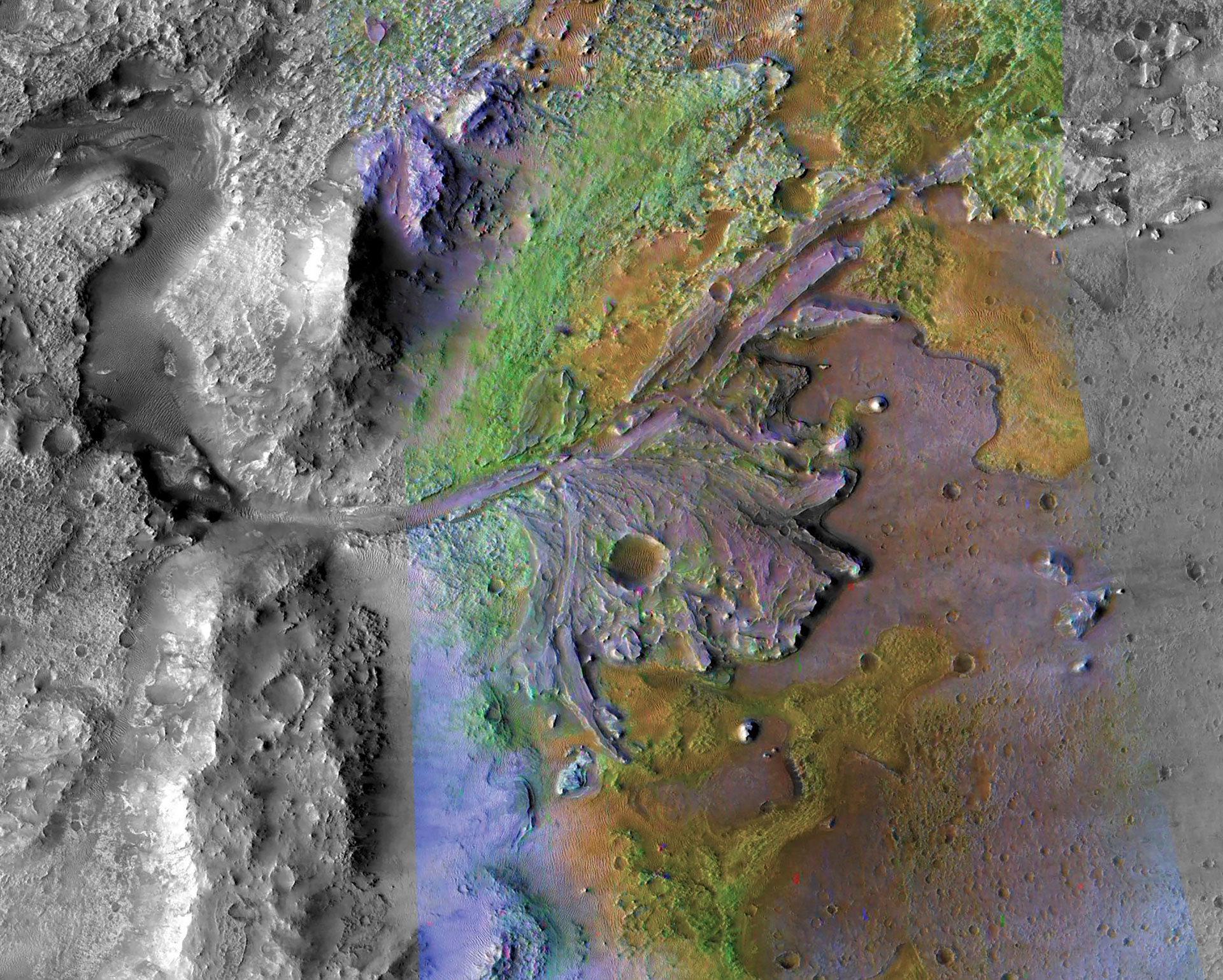
An aerial photo shows the remains of a delta where a water source once fed an ancient lake at the Jezero crater on Mars. Credit: NASA/JPL-Caltech/ASU
Ground-penetrating radar reveals eons of environmental changes, offers hope that soil samples hold traces of life.
- Ground-penetrating radar onboard NASA’s Mars Perseverance rover has confirmed that the Jezero crater, formed by an ancient meteor impact just north of the Martian equator, once harbored a vast lake and river delta.
- Over eons, sediment deposition and erosion within the crater shaped the geologic formations visible on the surface today.
- The discovery of lake sediments reinforces the hope that traces of life might be found in soil and rock samples collected by Perseverance.
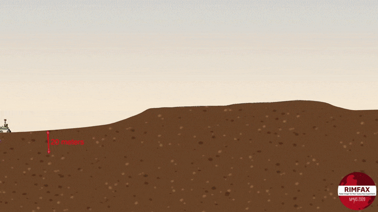
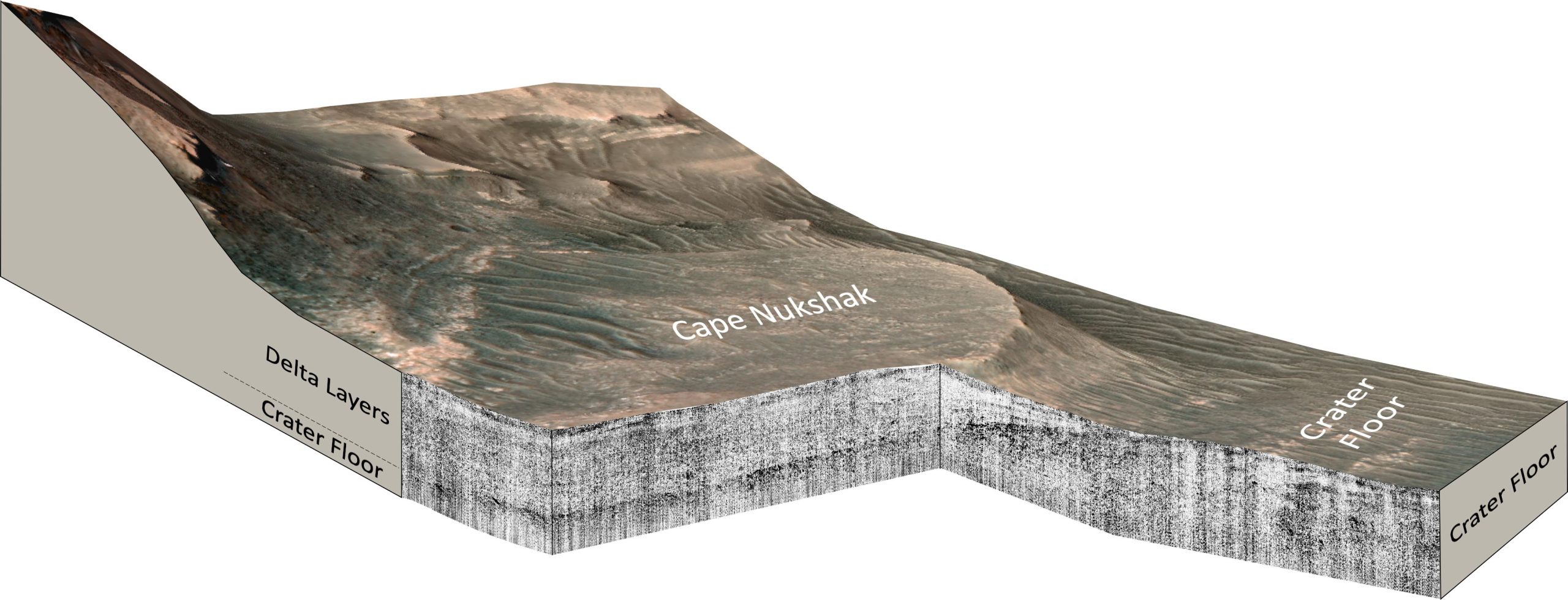
Animation showing the RIMFAX instrument on NASA’s Mars Perseverance rover acquiring ground-penetrating radar measurements across the contact between the crater floor and the delta in Jezero crater, Mars. Credit: Euibin Kim, David Paige, UCLA
If life ever existed on Mars, the Perseverance rover’s verification of lake sediments at the base of the Jezero crater reinforces the hope that traces might be found in the crater.
In new research published in the journal Science Advances, a team led by UCLA and The University of Oslo shows that at some point, the crater filled with water, depositing layers of sediments on the crater floor. The lake subsequently shrank and sediments carried by the river that fed it formed an enormous delta. As the lake dissipated over time, the sediments in the crater were eroded, forming the geologic features visible on the surface today.
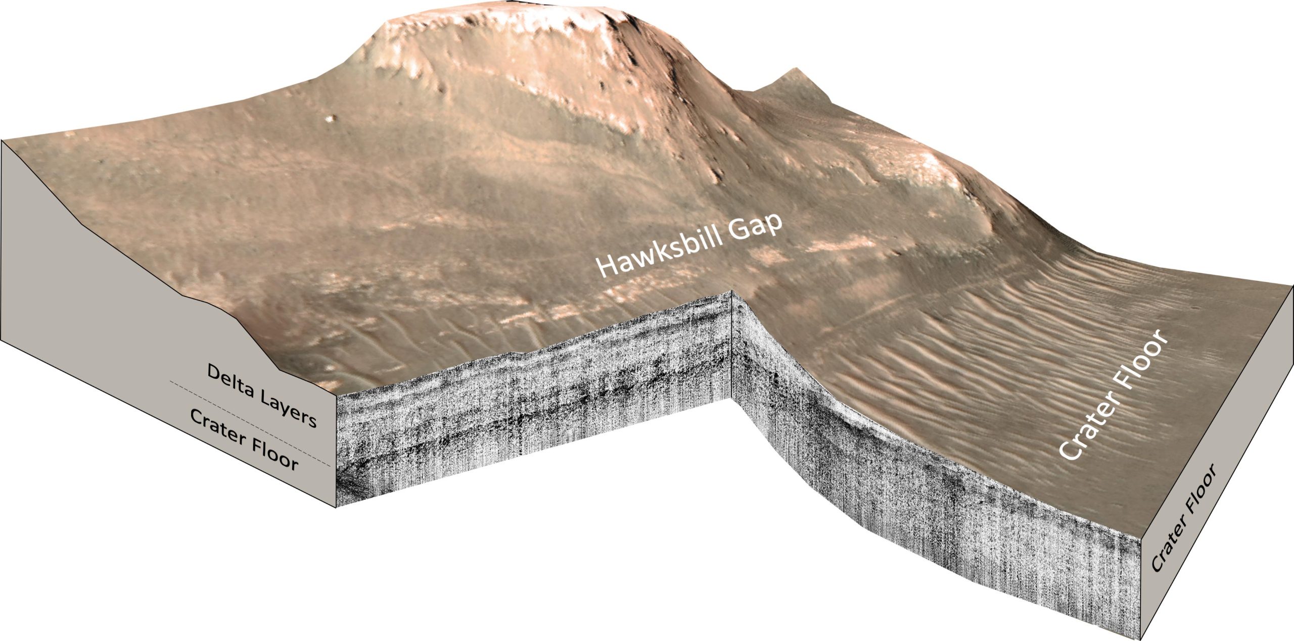
Mars Perseverance Rover RIMFAX ground penetrating radar measurements of the Hawksbill Gap region of the Jezero Crater Western Delta, Mars. Hawksbill Gap. Credit: Svein-Erik Hamran, Tor Berger, David Paige, University of Oslo, UCLA, California Institute of Technology Jet Propulsion Laboratory, NASA
The periods of deposition and erosion took place over eons of environmental changes, the radar indicates, confirming that inferences about the Jezero crater’s geologic history based on Mars images obtained from space are accurate.
“From orbit we can see a bunch of different deposits, but we can’t tell for sure if what we’re seeing is their original state, or if we’re seeing the conclusion of a long geological story,” said David Paige, a UCLA professor of Earth, planetary and space sciences and first author of the paper. “To tell how these things formed, we need to see below the surface.”
AI-interpolated video from NAVCAM images from the NASA Perseverance Rover as it traversed down the Jezero Western Delta from Cape Nukshak to the Crater Floor on Sol 641. Credit: Lior Rubanenko, Emily Cardarelli, Justin Maki, David Paige, UCLA, California Institute of Technology Jet Propulsion Laboratory, NASA
The rover, which is about the size of a car and carries seven scientific instruments, has been exploring the 30-mile-wide crater, studying its geology and atmosphere and collecting samples since 2021. Perseverance’s soil and rock samples will be brought back to Earth by a future expedition and studied for evidence of past life.
Between May and December 2022, Perseverance drove from the crater floor onto the delta, a vast expanse of 3 billion-year-old sediments that, from orbit, resembles the river deltas on Earth.
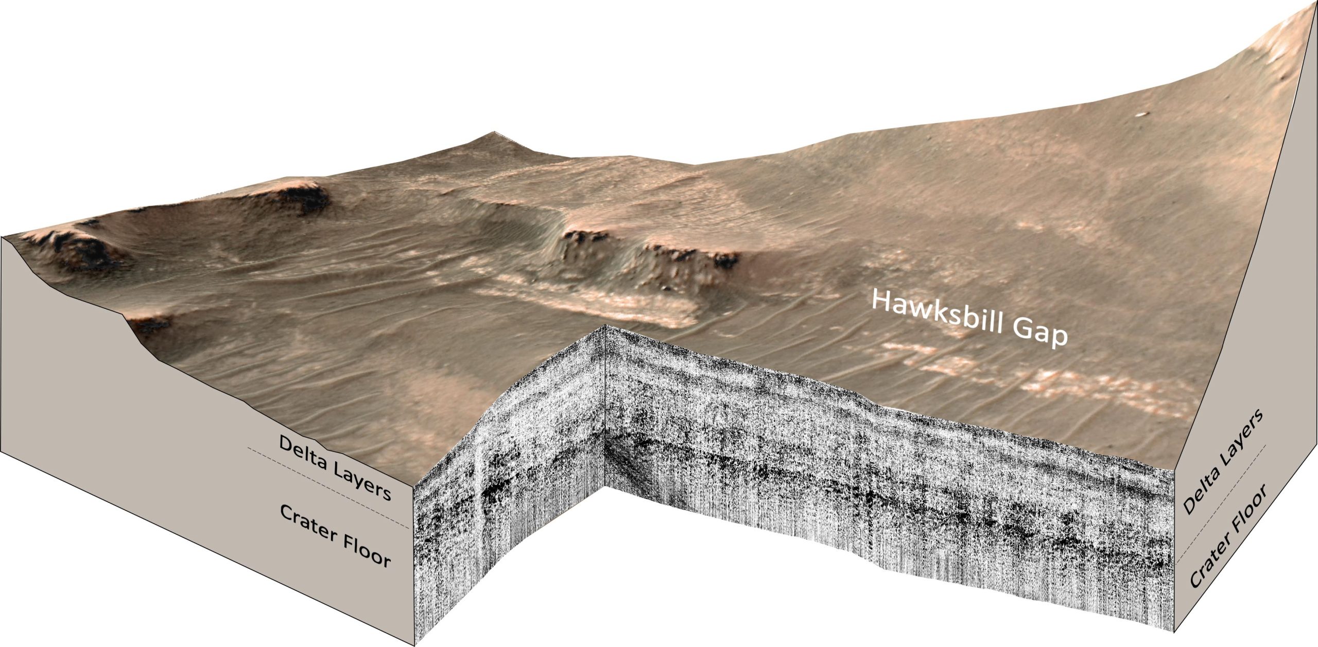
Mars Perseverance Rover RIMFAX ground penetrating radar measurements of the Hawksbill Gap region of the Jezero Crater Western Delta, Mars. Credit: Svein-Erik Hamran, Tor Berger, David Paige, University of Oslo, UCLA, California Institute of Technology Jet Propulsion Laboratory, NASA
As the rover drove onto the delta, Perseverance’s Radar Imager for Mars’ Subsurface Experiment, RIMFAX, instrument fired radar waves downward at 10-centimeter intervals and measured pulses reflected from depths of about 20 meters below the surface. With the radar, scientists can see down to the base of the sediments to reveal the top surface of the buried crater floor.
Years of research with ground-penetrating radar and testing of RIMFAX on Earth have taught scientists how to read the structure and composition of subsurface layers from their radar reflections. The resulting subsurface image shows rock layers that can be interpreted like a highway road cut.
“Some geologists say that the ability of radar to see under the surface is kind of like cheating,” said Paige, who is RIMFAX’s deputy principal investigator.
Mars Perseverance Rover RIMFAX ground penetrating radar measurements of the Cape Nukshak region of the Jezero Crater Western Delta, Mars. Credit: Svein-Erik Hamran, Tor Berger, David Paige, University of Oslo, UCLA, California Institute of Technology Jet Propulsion Laboratory, NASA
RIMFAX imaging revealed two distinct periods of sediment deposition sandwiched between two periods of erosion. UCLA and the University of Oslo report that the crater floor below the delta is not uniformly flat, suggesting that a period of erosion occurred prior to the deposition of lake sediments. The radar images show that the sediments are regular and horizontal — just like sediments deposited in lakes on Earth. The existence of lake sediments had been suspected in previous studies, but has been confirmed by this research.
A second period of deposition occurred when fluctuations in the lake level allowed the river to deposit a broad delta that once extended far out into the lake, but has now eroded back closer to the river’s mouth.
“The changes we see preserved in the rock record are driven by large-scale changes in the Martian environment,” Paige said. “It’s cool that we can see so much evidence of change in such a small geographic area, which allows us extend our findings to the scale of the entire crater.”
Reference: “Ground penetrating radar observations of the contact between the western delta and the crater floor of Jezero crater, Mars” by David A. Paige, Svein-Erik Hamran, Hans E. F. Amundsen, Tor Berger, Patrick Russell, Reva Kakaria, Michael T. Mellon, Sigurd Eide, Lynn M. Carter, Titus M. Casademont, Daniel C. Nunes, Emileigh S. Shoemaker, Dirk Plettemeier, Henning Dypvik, Sanna Holm-Alwmark and Briony H. N. Horgan, 26 January 2024, Science Advances.
DOI: 10.1126/sciadv.adi8339
The research was funded by NASA, the Research Council of Norway, and the University of Oslo.